Wind speedmph |
TemperatureF |
Wind Direction |
Relative Humidity% |
Burn Timehour(s) |
|
| Drag points to change weather conditions. |
|
|
|
|
|
|
|
|
| Imports from |
Showing last 10 ignitions |
|
Reverse
Legend
|
| Time | Name | Acres |
|---|
| Historical Fires |
| California: 1878-2024 |
| United States: 2006-2024 |
Year: 2005 - 2018 |
Fire: |
| Id | Fire Name | Incident ID | Description | Start Time | User | Group |
|---|
| Name | Last Modified |
|---|
| Edge: |
Fire: |
| Fire | |
| Start | |
| Stop | |
| Speed | |
| .... | |
Official fire perimeters are usually updated once a day for active fires.
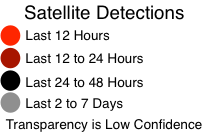
Satellite updates are approximately every 6 hours.
For more information about how to use this map, see our videos.
Firemap is created by WIFIRE. See the FAQ for details about the map.
Questions or comments? Contact us.
| Perimeter: | |||
| Spread Rate: | |||
| Flame Length: | |||
Firemap accounts are for fire agencies and researchers. Please register for an account only if you are in one of these groups. If you are not affiliated with a fire agency, you may not be contacted.
For more information about how to use this map, see our videos.
|
Probability
|
|
|
|
|
|
Opacity
|
|
|